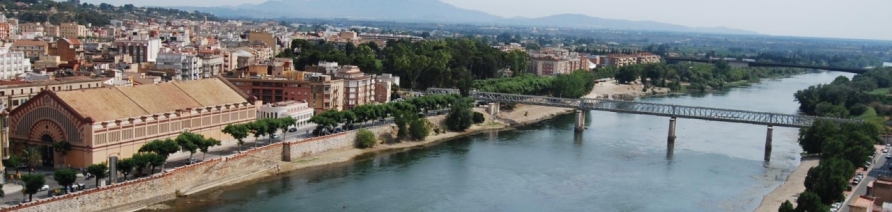
In the south of the Principality of Catalonia, along the banks of the lower Ebre River, just before it reaches the Mediterranean, we come to the city of Tortosa. Encircled by the Els Ports massif and the Cardó mountain range, the land forms a valley that extends the fertility of the vegetable plots right down to the unique landscape of the Delta.
The Principality’s main historic town in the south, Episcopal See and the capital of the county of Baix Ebre and the Catalan Ebre region, the city, which was historically located along the left bank of the river, has now spread out along both banks. On the left-hand side, in the shadow of the Castell de la Suda, there is the historic centre, the Eixample districts and the villages of Bítem and Campredó. On the right, we find the neighbourhood of Ferreries and the villages of Jesús, Reguers and Vinallop.
The Municipality
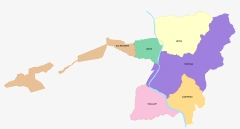
The Villages
With more than 30,000 inhabitants and an area of 218.5 km2, the city is an important historical, cultural, tourism and service centre in the Terres de l'Ebre region. Tortosa is the headquarters of the judicial district, the regional healthcare centre and the Episcopal See.
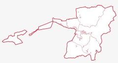
The municipal area of Tortosa covers a considerable area of 218.5 km2.. As well as the city itself, (located 12 m above sea level at the railway station), the main villages in the Tortosa municipal area are Jesús (17 m), Bítem (19 m) and Campredó (20 m), all three of which are Decentralized Municipal Entities, and the parishes of Reguers (97 m) and Vinallop (20 m) In addition, there are the villages of Mianes, Font de Quinto, La Masada d'en Gassol and Santa Rosa de Lima. Moreover, the municipal area includes the enclaves of Bassa dels Ganduls and Mola de Catí, in the national park of Els Ports de Tortosa-Beseit, more than 1,300 m above sea level.

Until the 1970s, the municipality of Tortosa covered and area of 424.3 Km2, but this period saw the start of the segregations of Deltebre (1977), Camarles (1978), Sant Jaume d’Enveja (1978) and L'Aldea (1983). To the east, it borders the municipal areas of Perelló, Camarles and L'Aldea, to the south, Amposta, Masdenverge and Santa Bàrbara, to the west, Roquetes, Alfara de Carles and Beseit, and to the north, Aldover and Tivenys.
Therefore, the current municipal area of the capital of the county of Baix Ebre stretches from the start of the delta plains right up to the considerable heights of the medium mountains of the Cardó-Boix range and especially the peaks of the massif of Els Ports de Tortosa-Beseit.
With respect to the geographical features of the area, we transcribe an adapted excerpt from the Gran Enciclopèdia Catalana:
Tortosa's extensive territory is basically comprised of two large notably differentiated sectors, each with their own very distinct features, both in terms of the modelling and the composition of the land, vegetation, crops, etc. The first area is the Ebre Valley, the main backbone of the county and indeed the municipal area, which crosses the Ebre Valley in a northerly to south-easterly direction, from Aldover and Tivenys. It is a broad band of land that narrows on the left-hand side due to the presence of the Cardó mountain range. The Catalan Pre-Coastal Range is the second feature that defines the municipal area. It includes, to the left of the River Ebre, the Cardó mountains and, to the right, the Els Ports de Tortosa national park. In this region, the Pre-Coastal mountain Range meets the Iberian System, with no option for continuity and, as a result, the direction of the strata vary between one place and another, although the most general direction is from north-east to south-west.
The massif of Els Ports de Tortosa-Beseit is one of the most important and highest geological features in the Tortosa region and, indeed, in the entire province of Tarragona. The massif marks a clear separation between the Ebre Valley and the inland region (Terra Alta and Matarranya to the north and Baix Maestrat to the south) and, historically, the landmark was the meeting point of the kingdoms of Aragon and Valencia and the Principality of Catalonia. It is a predominantly limestone formation from the Mesozoic period, which the Alpine paroxysm buckled and raised, without creating shapes that were particularly jagged due to the prevalent Jurassic materials, together with the dolomite rocks. These tectonic movements had there most significant impact on the chalk marl substrate. These folds usually run in a north-east to south-west direction. With respect to vegetation, the area of Els Ports de Tortosa can be differentiated into two categories depending on the direction the slope is facing. While the east-facing slope is wild and unruly, the slope in the shade has a great wealth of woodlands and wildlife.
The other important geological formation that shapes the municipal area of Tortosa is the Cardó mountain range, to the left of the Ebre River. Encircling the Cubeta de Móra basin to the north and east, the Cardó massif stretches southward along a number of peaks, some of which fall within the municipal area, such as the Collredó mount (381 m) to the far south. A little further north, on the municipal border between Tortosa and Tivenys and El Perelló, the Boix mountain range comes to an end, with the Morral de Cabrafeixet range. The stretch of the Cardó mountain range that falls within the municipal area has a number of geological features: the Punta de Montaspre peak, the Tossal de les Coves del Llamp hill, L'Enclusa (645 m), the Tossal de l’Alentar hill, the Punta dels Estrets peak, the Mola Porquera, the Coll Ventós hill and the Faixa Porquera. In lithological terms, the rocks date back to the Mesozoic Era, with limestone rocks that give rise to a landscape broken by chemical erosion, basically giving an undulating terrain. Due to its strategic importance, it is worth noting the Coll de l'Alba hill (372 m) to the east of the city of Tortosa. The crest of this section of the Cardó mountains marks a division between the Ebre River and the sea. Towards the river, the region is drained by the Buinaca, Corralisses, Coves, Montserrada, Estrets, Torrent and Rastre gullies. The Fullola stream flows into the sea and, for a fair stretch, it marks the municipal border with the El Perelló region. The stream is fed by the waters of the Povet, Galiassa and Barcelles gullies. Other streams originate on the lower southern foothills on the Cardó massif and the Collredó mountains, and empty into the gullies and channels on the delta plain, such as the Pixador stream and its tributary the Racó de l'Ermitana gully, which are part of the border with the municipality of L'Aldea, the Pont Trencat stream, etc.
The plains are covered by materials from the quaternary period that come from the different sedimentations that have taken place over the changes from one age to another, with its glacial and interglacial periods. The river has taken advantage of these stages to erode, transport and deposit sediment at the foot of the mountain, from the Mesozoic Era, both from the Jurassic and Cretaceous periods, to form this broad and extremely fertile plain and the delta itself.
As well as the primary base constituted by the Ebre River and its irrigation channels, the municipality's surface waters are distributed across an extensive network of seasonal gullies and streams, which are fed by rainwaters and flow into the river. Apart from those mentioned, other important gullies on the right bank of the Ebre River include the Pinyolriu and Cervera. It should be noted that all of these waters and also the springs in the massif of Els Ports de Tortosa are used to this day, an indication of which can be found in the name of the neighbourhood of Els Reguers (irrigation channels) located on the south-eastern slope of the massif of Els Ports. The irregular rain fall and limestone structure has made the subsoil rich in water, which has led to a proliferation of vegetable allotments and wells in the dry lands. In other cases, the rainfall itself has been used through the construction of cisterns outside the country houses, in the stretches of dry land.
The municipal area has a Mediterranean climate characterized by temperatures varying around 14ºC and rainfall that does not exceed 600 mm⁄year. Wind is another important feature of the weather in Tortosa. Particularly noteworthy are the northerly winds, the Tramuntana and Vent de Dalt ('wind from above'), which make use of the Ebre Valley as a channel.
The predominant native vegetation is cork oak forest, which has been depleted and replaced by different varieties of pine, depending on the altitude, orientation, etc. As such, we can find everything from stone pines to Aleppo pines and Scots pines along the course of the mountain chain. Cork oak forest is usually accompanied by laurestine and pistacia lentiscus but, as there is such low rainfall in this region, the cork oak has been replaced and the woodlands have made way for areas of maquis and phrygana shrubland. A key feature is the massif of Els Ports de Tortosa. The municipal area of Tortosa has lands in three areas of natural interest: the Illes de l'Ebre, Els Port de Tortosa-Beseit (declared a National Park) and the Cardó-El Boix mountain range.
More useful information: